

The new National Planning Policy Framework (NPPF)[1] replaces the December 2024 framework, delivering the most significant reset to transport planning in years.
While early headlines have focused on station-led growth catchments and minimum densities, the operational shifts across Policies TR1–TR8 will reshape day-to-day development management. The central message is clear: transport must shape the vision of a place from day one, not arrive late to justify a fixed masterplan.
Critically, vision-led planning does not replace the impact test, it redefines how impacts are evaluated and mitigated
A new structure - and a new shorthand
The transport chapter is now set out as policies TR1-TR8. TR1 and TR2 are plan-making policies; TR3-TR8 are national decision-making policies. The wider Framework follows the same split between plan-making and decision-making.
That may sound administrative, but it matters. The national decision-making policies are material considerations for planning applications, while the plan-making policies are not intended to be applied directly to proposals. We will all need to get used to citing policy codes rather than familiar paragraph numbers. "TR6" is likely to enter the transport planner's vocabulary fairly quickly.
Vision-led planning is now the starting point
The Framework defines a vision-led approach as setting the outcomes needed to create a well-designed, sustainable, inclusive and popular place, then identifying the transport solutions required to deliver them. That is deliberately different from simply forecasting demand and providing more highway capacity in response.
This should move transport work earlier in the design process. The transport vision, land-use mix, density, street network, active travel connections, public transport improvements, parking and demand-management measures should be developed together. A Transport Assessment written after the layout is fixed will struggle to demonstrate that transport has genuinely shaped the scheme.
This is not entirely new in practice. Many progressive authorities and project teams are already working in this way. The important change is that it is now embedded throughout national policy, from site selection and sustainable location through to design, mitigation and monitoring.
The days of reaching first for a junction model and trying to widen our way out of every issue are, hopefully, behind us. Modelling still has a role, but it should test the vision and reasonable scenarios rather than become the vision itself.
The Connectivity Tool is important, but it is not the answer on its own
Policies TR1 and TR3 say that the Department for Transport's Connectivity Tool should be used when considering site selection and the connectivity of development locations. We should therefore expect it to feature in local plan evidence, site promotion, Transport Assessments and objections.
The final wording is helpful though; it expressly places the tool alongside other quantitative or qualitative evidence. The Government's consultation response confirms that this was deliberate, including in response to concerns about rural areas and the relationship with tools such as PTAL.[3]
That means local evidence and professional judgement remain entirely relevant: PTAL-type assessments, route audits, service frequency and reliability, public transport capacity, access to day-to-day facilities, topography, severance, planned infrastructure and observed travel behaviour may all add something that a national tool cannot capture.
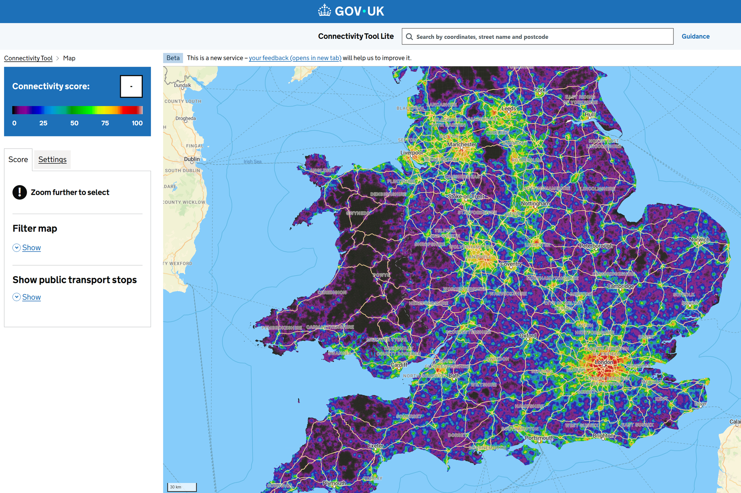
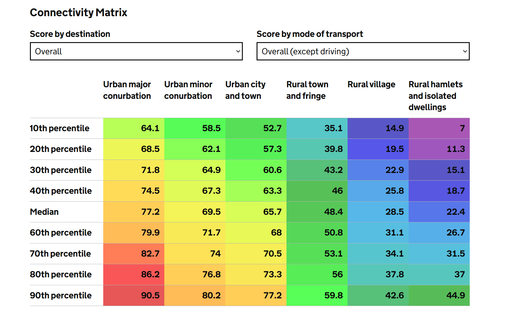
My view is fairly straightforward. Use the Connectivity Tool as an evidence source, not as a pass-or-fail score. As the guidance for the DfT Connectivity Tool states: “the score is a relative measure, not an absolute measure of connectivity – it shows how places compare to other places”[4]. If its output helps explain the site, use it. If it misses something important, evidence that properly. An attractive map cannot turn an inaccessible route into a good one, and a weak national score should not close down a well-supported local case.
Sustainable locations, stations and the 800-metre question
Policy TR3 establishes that development generating significant movement should be located where sustainable travel is viable or can be delivered.
For station-led growth outside existing settlements or within the Green Belt, the Framework sets specific thresholds:
The 800-Metre Metric: Policy benchmarks "reasonable walking distance" at approximately 800 metres (a 10-minute walk). However, an 800m radius on a masterplan is not a walkability assessment. Topography, directness, lighting, and perceived safety dictate real walking catchments.
Beyond the Policy Benchmark: In practice, some active pedestrians would be happy to regularly walk 1,200m to 1,600m (15–20 minutes) to reach rapid transit, particularly where CPZs, parking restraint, and active travel corridors make driving the least convenient option.
"Well-Connected" Criteria: These apply to rail, light rail, tram and Underground stops in the top 80 English Travel to Work Areas by GVA, running at least 4 daytime services per hour (or 2 per direction).
TR6: “severe” stays - and the refusal test is clearer
For development management, TR6 is probably the policy to read twice.
Transport Statements and Transport Assessments must be proportionate to the nature and scale of the development. Travel Plans remain required where a proposal is likely to generate significant movement. Both must now reflect not only the transport vision for the development, but also the transport strategy for the area, including fallback measures where the first Travel Plan interventions do not deliver the expected outcomes.
The assessment should consider movement patterns and reasonable future scenarios, including relevant times of day, cumulative effects, multimodal trip generation and measures to promote sustainable travel. The change from "all reasonable future scenarios" in the draft to "reasonable future scenarios" in the final version is small but sensible: it supports a proportionate scope rather than an endless modelling exercise.[2][3]
Most importantly, the final policy says proposals should be refused where they would have a severe adverse effect on network capacity or congestion, including cumulative effects, or an unacceptable highway-safety effect. Proposed mitigation and wider network improvements are taken into account, including measures which support sustainable movement.
The final sentence matters too: this test applies during construction as well as after completion. Construction Logistics Plans and Construction Traffic Management Plans have therefore become more important at application stage, particularly where routes, schools, sensitive frontages, network peaks or major concurrent projects create a credible risk.
This does not mean every scheme needs a disproportionately onerous assessment; it should remain proportionate and robust. The scenarios, time periods, cumulative developments, construction assumptions and mitigation strategy should be agreed early and explained clearly.
The Two Routes to Transport Refusal: TR6 vs DP3
A satisfactory junction-capacity model is not, by itself, sufficient to demonstrate policy compliance. Two relevant policy routes to refusal are particularly important:
Impact & Safety (Policy TR6): Proposals face refusal if they cause a severe adverse effect on network capacity/congestion (cumulatively) or an unacceptable highway safety effect. Crucially, this test now explicitly applies to construction logistics, not just operational traffic.
Movement and design (Policy DP3): Proposals should be refused where, without clear justification, they conflict with the relevant design principles including prioritising walking, wheeling, cycling and public transport, or with explicit design standards in the development plan.
A key takeaway is that application material including Transport Assessments and, where required, Design and Access Statements, should present an integrated strategy from the outset.
Walking, wheeling and cycling - with a stronger focus on inclusioN
The consistent use of "walking, wheeling and cycling" is welcome. "Wheeling" is defined around wheelchairs, mobility scooters and similar mobility aids, making the inclusive mobility expectation much clearer than an approach framed only around pedestrians and cyclists.
TR4 adds practical detail: permeable street networks, continuous footways, segregated cycle facilities, lighting, seating, accessible cycle parking and good waiting facilities. It also expressly requires streets and routes to be safe, inclusive and attractive for everyone, with particular attention to women and girls, people vulnerable to crime or the fear of crime, disabled people, older people, children and those with limited mobility.
That should influence much more than a standard access drawing. Route choice, natural surveillance, lighting, crossing arrangements, gradients, places to rest, wayfinding and the quality of the journey to public transport all need to be considered. It is a stronger Healthy Streets and movement-and-place message, and a good one.
There is still comparatively little on wider micromobility. E-scooters appear in the plan-making policy for parking, but the Framework does not really grapple with how newer forms of shared or powered micromobility should operate within developments and public space. That conversation will continue locally.
Parking: restraint, shared transport and some welcome pragmatism
TR2 supports maximum parking standards where they help promote sustainable modes and shared transport, make better use of connected locations or manage the road network. The old requirement for "clear and compelling justification" before setting maximum standards has gone.
Parking standards should respond to connectivity, local car ownership and travel trends, opportunities for walking, wheeling, cycling and public transport, car sharing, electric charging, Blue Badge needs, cycle and e-scooter demand, and legitimate commercial requirements. The express reference to shared transport is useful: car clubs, cycle hire and similar arrangements can form part of a credible strategy to reduce the need for private parking where appropriate.
TR4 also introduces a pragmatic flexibility for the reconfiguration of retail and other customer-facing sites where better use of previously developed land is proposed but evidence shows that a particular level of parking must be retained for operational or commercial reasons. That should allow a more grown-up discussion than simply applying a maximum figure without understanding how the site works.
One subtle glossary change is worth noting. Ultra-low and zero-emission vehicles and car sharing are no longer included within the definition of "sustainable transport modes"; the definition now centres on walking, wheeling, cycling and public transport. That does not mean electric vehicles and car clubs are discouraged (both appear elsewhere in policy) but it rightly avoids treating a cleaner or shared private vehicle as equivalent to reducing car travel in the first place.
Other changes worth having on the radar
A few extra takeaways I believe we should be thinking about:
Medium development is now defined. It means 10-49 homes on sites up to 2.5 hectares. It remains a subset of major development, so major housing policies generally still apply.
Large-scale growth does not need to pretend to be self-contained. The Framework expects sustainable access to jobs and services within or beyond new settlements, but warns against an unrealistic level of self-containment.
Roadside facilities have their own policy. TR5 supports safety, driver welfare, alternative fuels and overnight lorry parking, and protects existing facilities unless suitably replaced or demonstrably no longer needed or viable.
Aviation and new mobility are explicitly recognised. TR7 covers ports, airports and advanced air mobility; its footnote includes droneports (see our previous article on this!), vertiports and autonomous-vehicle facilities. The future has arrived in policy sooner than many expected.
Public rights of way receive stronger protection. TR8 now requires proposals to protect and enhance the network, reflecting its role in active travel, access and wellbeing.
The main theme is fairly consistent. The Government has retained the vision-led approach but responded to concerns about evidence, clarity and enforceability. Applicants have more scope to use local and qualitative evidence alongside national tools, while decision-makers have clearer wording on mitigation, design and refusal.[3]
What should projects teams being doing now?
In my view, we need to:
Lead with a ‘Movement Vision’: Define mode-share targets, active travel spines, and street hierarchy before fixing site layouts and building footprints.
Treat the DfT Connectivity Tool as baseline data: Use the tool to establish baseline context, but supplement it with local qualitative evidence, route audits, and public transport frequency data.
Undertake baseline studies and scoping earlier: Agree on reasonable future-year scenarios, cumulative developments, and multimodal assumptions with the highway authority at pre-app.
Front-load construction logistics planning: Identify HGV routing, sensitive receptors, school-run clashes, and peak-hour controls before submission rather than relying entirely on outline planning conditions.
Wider integration of the healthy streets active travel zone assessment approach beyond London: Walk and wheel the pedestrian corridors off-site. Assess dropped kerbs, continuous footways, lighting, and severance rather than relying on straight-line catchment maps.
Align mitigation with the Vision: Direct Section 106 and infrastructure funding toward active travel links, bus priority, and public realm improvements before designing vehicular capacity expansions.
A positive direction… but with more to do!
There is a lot to welcome in the 2026 Framework. Transport is treated less as a problem to be tested after design and more as a way to direct the masterplan and unlock well-connected, higher-density and inclusive schemes. The stronger wording on walking, wheeling, safety and movement design should help create better places, while the acknowledgement of local evidence avoids turning the Connectivity Tool into a national black box.
The final text is also tougher than the draft where it needs to be. Severe network effects and unacceptable highway-safety impacts remain capable of stopping a scheme. Construction effects are expressly included. Poor movement design can create a separate refusal risk under DP3.
The practical message is therefore not that modelling or mitigation have disappeared. It is that they now sit within a broader, place-led story.
Get the vision right, evidence it properly and show how the scheme will work - during construction, on opening day and as travel behaviour changes over time. That is a better basis for transport planning and will lead to better-designed schemes.
Footnotes
[1] Ministry of Housing, Communities and Local Government, National Planning Policy Framework, August 2026: https://assets.publishing.service.gov.uk/media/6a8334c03bd75b81e2329ac4/National_Planning_Policy_Framework.pdf
[2] Ministry of Housing, Communities and Local Government, National Planning Policy Framework: draft text for consultation, December 2025: https://assets.publishing.service.gov.uk/media/697b71c52ff8d10a830d5d4a/Draft_NPPF_December_2025.pdf
[3] Ministry of Housing, Communities and Local Government, Government response to the proposed reforms to the National Planning Policy Framework and other changes to the planning system consultation, August 2026: https://assets.publishing.service.gov.uk/media/6a82fcec3bd75b81e2329a89/National_Planning_Policy_Framework_consultation_-_government_response.pdf
[4] Department for Transport: Interpreting Connectivity Scores and the Connectivity Matrix: https://connectivity-tool.dft.gov.uk/help/interpreting-connectivity-scores


